|

Times are GMT (UTC, Z). Observations at this station [ ] are 24-h 09-09 GMT, some others { } occasionally refer to other 24-h periods, extremes (first indications) are given in bold and are usually 21-21 GMT. When averages are referred to (.) compares with the last decade and [.] with the new 30-y climatological average [1981 - 2010]. All data are subject to verification and amendment.
June 2018
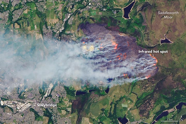
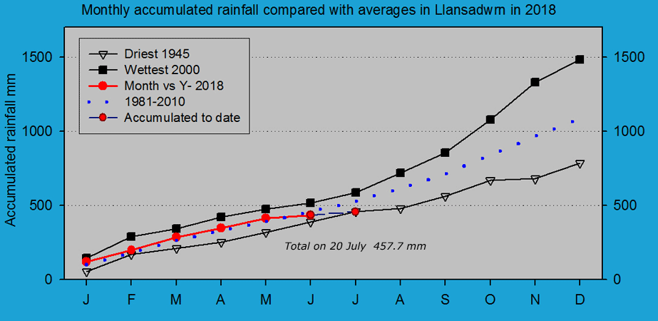
The first 15-days were dry with 17.5 mm of rainfall (21%) & [36%] of the monthly average. Temperatures were generally on the warmer side with the mean 15.5C [+1.6] of the 30-year average. Dull with slight rain and drizzle from the start on the 16th with very poor visibility. The garden could do with some rain with 3.0 mm recorded at 0900 GMT, but it will take more to restore the water balance of the surface soil. Brighter and drier in the afternoon (Weybourne 21.6C Hawarden 20.2C Killylane 16.4 mm Capel Curig 14.0 mm Lerwick 12.3h) [Max 16.7C Min 9.4C Rain 2.5 mm]. Overcast and dull with low cloud on the Snowdonia Mountains on the 17th with a complex of frontal systems over Britain. Low 1005 had moved over the N Sea while low 985 mb S of Greenland was moving eastward. Pressure was high 1032 mb Azores and 1021 mb E Baltic (Scampton 20.2C Tulloch Bridge Min 2.0C Scolton CP 4.8 mm Kirkwall 6.1h Aberporth 2.5h) [Max 17.4C Min 11.4C Rain nil]. The 18th remained mostly cloudy but there was some weak sunshine at times. Low 977 mb was SE Iceland, but pressure 1017 mb was rising with high 1031 mb Azores to the Bay of Biscay. Moderate fog developed late in the evening (Heathrow 26.6C Salsburgh Min 8.9C Cassley 8.4 mm Shoeburyness 10.0h) [Max 16.7V Min 11.7C Rain 0.5 mm]. Another dull day in this part of Anglesey on the 19th which kept enveloped in cloud and mist in the afternoon. It was brighter in Beaumaris and on the mainland in Llanfairfechan, and NW Anglesey where there was some sunshine. Here, a sunless day (Writtle 25.6C Usk 22.0C Katesbridge Min 3.5C Derrylincornahoule 16.6 mm Lerwick 9.2h Hawarden 5.6h) [Max 17.0C Min 10.0C Rain 0.9 mm]. An Atlantic-high 1029 mb was S of Greenland, but it began very dull again on the 20th with mist, moderate visibility and slight drizzle. A cold front over Wales associated with low 1007 mb Tay Estuary resulted in a temperature fall of 4C between 10 and 15 GMT before recovering later becoming brighter with a little sunshine (Teddington 26.3C Dalwhinnie Min 6.6C Edinburgh Botanical Garden 33.6 mm Capel Curig 18.2 mm Lerwick 12.0h Aberdaron 6.5h) [Max 16.1C Min 13.9C Rain 0.5 mm]... The 26th began very fine and warm the temperasture at 0900 GMT already 24.2C with 53% relative humidity. Just 3 oktas of cirrus and some contrails in the sky with very good visibility. Pressure was on 1026 mb with the high the UK high centred just off Aberdeen, Scotland. A mass of frontal cloud could be seen low in the sky to the NW off N ireland, but it did not encroach here. It was the warmest day of the month with 27.8C. Somewhat cloudy beginning the 27th, but warm. At 0900 GMT with pressure steady on 1026 mb the temperature was 24.1C with a relative humidity of 48% and here was a light ENE'ly breeze. The month ended with a rainfall total of 21.9 mm (26%) & [32%] of averages, least since 1988. The mean temperature 16.0C was (+1.9) & [+2.1] of averages highest a the station since before 1979. Sunshine at RAF Valley was 291.8h, most on the Anglesey record since 1931.
July 2018
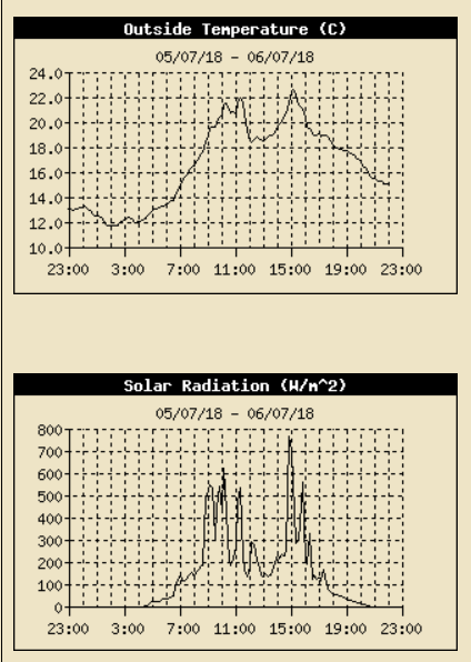
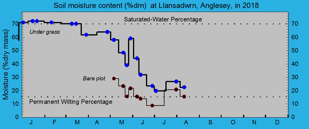
July 1 - continued with the heatwave. Very fine and sunny pressure 1015 mb was rising with a few cirrus clouds to start and some more by afternoon. A thundery low 1007 mb had developed over Biscay and storms moved from central France through Brittany into in the Channel and affected parts of SW England and S Wales for a time. (Heathrow 31.8C Porthmadog 31.0C Okehampton 20.6 mm Mumbles Head 10.0 mm Morecambe 16.4h Valley 15.1h) [Max 23.5C Min 13.3C Rain nil]. Much the same on the 2nd with little in the way of cloud. Pressure 1019 mb was rising with high 1023 mb over Scandinavia with a ridge to Scotland from Azores high 1032 mb. Thunderstorms continued over France. Wild fires were reported on Bangor Mountain, at Carmel near Caernarfon and Newborough Forest seemingly set by camping stove, but was extinguished by attending North Wales Fire and Rescue Service (Bournemouth 31.1C Porthmadog 30.7C Valley 25C Middle Wallop 5.4 mm Cardiff 0.2 mm Morecambe 16.2 Hawarden 15.5h) [Max 23.8C Min 13.4C rain nil]. Hardly a cloud in the sky on the morning of the 3rd that was very fine with very good visibility. Haze increased through the day and a distinct layer was seen against the mountains by evening. At Aberffraw the fixed dunes were looking very dry with few of the usual plants, including thymes and pansies, putting on their usual show. The willow slacks were still green and I was pleased to find plants of the rare dune helleborine Epipactis dunensis although these too were dried and not flowering or in their usual numbers as they should. The sea temperature when 1 m deep was 22C on the incoming neep tide at 3 pm with an air temperature of 24C. There were a few purple jellyfish about 10-12 cm diameter with thick tentacles swimming in the water below the surface (Porthmadog 30.1C Kinbrace 4.3C Culdrose 0.8 mm Morecambe 16.3h Valley 16.0h) [Max 22.6C Min 13.1C Rain nil]. Similar again on the 4th, very fine with good visibility not clear as their was light haze. At 0900 GMT the grass is dry, but earlier there is slight guttation at the tips of leaves in the greener areas. Some grass on shallow soil is dry and yellowing as are the roadsides that look more like the southern French autoroutes. The local farmer began cutting grass on an adjacent field today and completed the operation and gathering in the day. It is the 14th day without measurable rain and with soils now very dry grass growth has slowed markedly and yields are less than normally expected. Soil under grass has a moisture content of 19.7% dry mass while on the bare met plot it has fallen to 15.4% dm. Some mature trees on shallow soils are showing some signs of early wilting and vegetables need irrigation every day (Giants Causeway 29.1C Porthmadog 27.5C Katesbridge 4.7C St Athan 8.0 mm Morecambe 16.4h Valley 15.5h) [Max 25.2C Min 13.8C Rain nil]. A lovely fine day on the 5th starting with just 2 oktas cloud cover a small cumulus and cirrus, but haze had thickened and visibility was moderate. Pressure 1017 mb was rising in high-pressure W of Ireland with a weak cold front lying over N Ireland and Scotland. There was a thundery low over Brittany and during the day 7 cm diameter hail fell on the Charente, France. Many properties had their tiles roofs considerably damaged. Glasshouse panes were shattered and car windscreens broken as well as damaging crops and vines. At Aberffraw the fixed dunes were dry and yellowed with the usual flowering plants in short supply, even thymes that normally are brilliant at this time of year were poor. The plants of the dune helleborine were still not opening their flowers in the parched conditions. High tide was at 3 pm and the water temperature out a 1 m depth was a pleasant 22C just right for a dip. The air temperature at Valley was 19.2C, but probably warmer in the sun on the beach sheltered from the off shore breeze. There were a few jellyfish swimming below the surface of the water, purple coloured with some thick tentacles (Coton-in-the-Elms 31.2C Usk 29.1C Ravensworth 6.1C Resallach 2.2 mm Morecambe 15.7h) [Max 21.8C Min 13.8C Rain nil]. An almost cloudless morning on the 7th, very fine, sunny and warm at 0900 GMT 19.9C soon 20C. Pressure remains steady on 1025 mb with high 1025 mb over the North Sea. There were lows 1003 mb Denmark Strait, 1017 mb Spain and 1013 mb Tunisia, but nothing to concern us on Anglesey. Again we got some convergence cloud formation overhead through the day, until 1300 GMT we had mostly S'ly breezes and the temperature rose to 24.7C by 1214 GMT. Then cooling a little as the sea breeze arrived from the NE and later to rise again and with the breeze dying away in the evening it was very pleasant and 20C until 8 pm (Charlwood 31.5C Usk 29.6C Tulloch Bridge 0.9C Morecambe 16.0h Hawarden 15.1h Valley 13.8h) [Max 24.7C Min 14.1C Rain nil]. Again little cloud to be seen on the 8th, very fine and mostly sunny and feeling very warm. At 0900 GMT with pressure steady on 1017 mb with high 1028 mb positioned off SW Ireland the cold front over N Scotland and W of Ireland keeping in the wings. A little of the Llansadwrn convergence cloud formed at times, but it did not stop the temperature rising to 26.4C, the highest of the month. Soil surfaces very dry with small cracks as no rain for 17 days, the grass is not growing. Picked the first sweet pea flowers for the house and Oregon sugar pod mange-touts for dinner (Coton-in-the-Elms 31,6C Usk 31.3C Bala Min 8.4C Aboyne 4.8 mm Shawbury 15.7h Hawarden 15.4h) [Max 26.4C Min 14.1C Rain nil]. A bright and warm morning on the 15th with a pleasant 20.1C at 0900 GMT. Six oktas cloud cover with some moderately developed cumuli in the vicinity, along with altocumulus and cirrus, with a gusty SSW'ly breeze at times . Continued dry and breezy with sunshine in the afternoon and a maximum of 23.1C. The wind run for the 24h was 147 miles, most this month so far, continuing the high evaporation rates. Mostly cloudy during the evening with frontal cloud encroaching associated with low 993 mb S Iceland at midnight, that had been giving rain in Ireland, moving over the Irish Sea. Some light rain and or drizzle from 2245 GMT with a temperature of 17C (Santon Downham 30.8C Redesdale 7.2C Thomastown 23.0 mm Bournemouth 15.1h) [Max 23.1C Min 15.8C Rain 3.9 mm]. The first 15-days were dry with just 5.1 mm of rainfall (5%) & [7%] of the monthly average. Temperatures had continued on the warmer side with the mean 18.3C (+2.6) and [+2.5] of the averages. Slight rain and drizzle continued after midnight on the 16th and by morning I was able to measure 3.9 mm of rain. The rain had ceased, but the morning remained dull and damp with little or no wind. Pressure was on 1014 mb with a band of frontal cloud crossing associated with low 994 mb S Iceland. Further showers in the afternoon heaviest 11 mm/h at 1256 GMT, then mostly cloudy into the evening with a glimpse of sunshine later. A colder day than of late the temperature around 16C, continuing warm in the S with Aberporth the wettest (Gravesend 31.5C Usk 25.4C Katesbridge 9.1C Aberporth 19.6 mm Herstmonceux 12.0h) [Max 16.2C Min 13.5C Rain 8.1 mm]. Brighter start to the day on the 17th with the stratocumulus cloud beginning to break up with sunny spells developing rather slowly. Pressure was on 1015 mb with low 1010 mb over the North sea. It was the afternoon before some reasonable spells of sunshine came along with a gentle breeze to dry the ground (Gravesend 25.8C Usk 23.3C Braemar 5.9C High Mowthorpe 13.6C Herstmonceux 12.1h Valley 7.0h) [Max 20.0C Min 12.9C Rain nil]. A cloudy very dull morning on the 18th with good , but hazy visibility, there was a little rain after 09 GMT. Pressure was on 1017 mb with a low 1015 mb Belfast, little (SW'ly) or no wind. Wales and the western fringes were covered with detached occluded frontal cloud not going far anytime soon. It did clear up in the afternoon with some sunny spells developing (Kew 26,8C Ravensworth 4.4C Porthmadog 5.6 mm Aberdaron 9.5h) [Max 20,2C Min 13.3C Rain 0.1 mm].
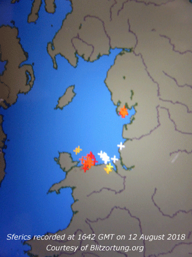
A very fine morning on the 19th, warm and sunny at 0900 GMT 18.7C (dewpoint 13.3C). An encroaching rain-bearing frontal cloud crossing the Irish Sea on the 20th brought dull, grey skies with slight rain from 0630 GMT. The 4.7 mm collected by 0900 GMT was welcome in the garden, but not enough to restore the water balance. The day kept overcast and sunless with further light to moderate rain in the evening. Mostly sunny and warm in the SE with a few scattered showers (Hull 28.4C Ravensworth 4.5C Drumnadrochit 27.0 mm Valley 9.4 mm Yeovilton 10.3h) [Max 16.3C Min 12.4C Grass 8.5C Rain 3.5 mm]. The month ended with a rainfall total of 47.2 mm (48%) & [68%] of averages, least since 2006 ranking 5th in Llansadwrn records since 1928. The mean temperature 17.4C was (+1.8) & [+1.7] of averages highest since before 2013 rank 5th in station records since 1979. Sunshine at RAF Valley was 265.3h, most on the Anglesey record since 2013 and 4th on the Anglesey record since 1931. August 2018August 1 - Fine, warm and breezy, but a mostly cloudy day some spots of rain in the morning with precipitation in sight on the mountains, brighter at times in the afternoon. A spell of light rain during the evening and a rising temperature through the night and was 16.3C at midnight (Santon Downham 26.9C South Newington Min 7.4C Killowen 21.4 mm Capel Curig 2.2 mm Shoeburyness 12.9 hours) [Max 19.6C Min 13.8C Rain 1.6 mm]. On the 2nd the sky was overcast and it was dull and muggy. Cloud was low on the Snowdonia Mountains and on Anglesey there was slight intermittent drizzle. At midnight the temperature was 16.3C and at 0900 GMT was 17.7C with 97% RH. The day remained cloudy until later in the afternoon when it was a little brighter with a glimpse of sunshine (Gravesend 30.6C Hawarden 26.8C Frittenden Min 9.4C Braemar 20.2 mm Capel Curig 5.0 mm) [Max 19.9C Min 17,3C Rain 0.1 mm]. Early in the day on the 3rd there was fog in Caernarfon Bay and along the W coast including Valley that was on military RED (runway closed until after noon). Here visibility was poor, sky looking grey to ground, with slight rain and or drizzle from about 0830 GMT. It was like that most of the day, there was one brighter spell late in the afternoon. Llanfairfechan had some sunshine with the temperature at Gorwel Heights 22C. During the evening an unusual dry thick fog developed, was not wetting any surfaces. The AWS temperature at 1900 GMT was 18.0C with 94% RH and at midnight it was 16.6C and 97% RH. Evaporation (PE) from M Albert Piche's evaporimeter in the Stevenson screen was zero today although the AWS calculated ET was 0.87 mm, lowest since 27 May 0.49 mm (Kew 33.2C Balmoral Min 11.1C Inverbervie 19.0 mm E. Malling 14.1h) [Max 19.5C Min 17.3C Rain 0.2 mm]. Thick fog continued after midnight on the 4th, but had cleared by 04 GMT. It was cloudier on the 6th, feeling warm as the cloud was thin moderately high altostratus allowing weak sunshine to penetrate. Pressure steady on 1016 mb with some sunny spells later in the afternoon and into the evening. A change was in the offing with low 996 mb S Iceland with a complex of frontal cloud over Ireland. Pressure was high 1019 mb over the Azores, 1016 mb Spain and 1021 mb Europe. Temperatures remained high in France (38C in Sarlat), Spain and Portugal [Max 21.5C Min 14.2C Rain 1.0 mm]. Dull and grey on the 7th with moderate to heavy drizzle and poor visibility. The drizzle had eased by 0900 GMT, although brightening a little the sky remained overcast. The change had arrived with a weak cold front slow moving over Wales and the West all down to low 991 mb lying to the NW. High-pressure 1020 mb continued over SE Europe and 1023 mb Azores. A thundery low 1009 mb off SW France was introducing some stormy weather there early in the day. Some sunny spells in the afternoon, fine a little cooler, turning cloudier by evening. Hot on the Continent with 43C recorded in Spain with a low minimum of 30.5C in Portugal. Cognac in France had 36.9C and Paris 34C. Within the Arctic Circle Ny Alesund had a max of 9.1C and min 4.1C while Svarlbard had a max 11.0C and a min 4.9C (Teddington 32.5C Hurn min 10.0C Achnagart 14.8 mm E Malling 14.1h) [Max 21.5C Min 11.2C Rain 1.0 mm]. The 10th began with some sunshine and showers more like April than August. Just a few spots at first then there was a heavier show at 0950 GMT that fell at a rate up to 63 mm/h; some hail was seen in the rain in Llanfairfechan. Pressure was steady on 1014 mb with a ridge to the W from Azores high 1028 mb. Showery trough were over several parts of Britain including Scotland and the South West. Low 997 mb SE Greenland had warm sector tropical air while there was a low 997 mb over the Baltic. A cooler feeling day with passing clouds, but feeling pleasantly warm the temperature rising to 18.0C in the afternoon during sunny spells (Bristol 21,2C Braemar 0.7C Hertmonceaux 49.8 mm Prestwick 11.2h Aberporth 10.4h) [Max 18.0C Min 9.9C Rain 3.5 mm]. A warm night with the temperature above 17C until the minimum of 16.3C at 0619 GMT on the 12th. The 13th began very dull and misty with spells of heavy drizzle. Pressure 1008 mb was rising with a frontal wave 1004 mb over the N Sea off Newcastle and to the W a cold front associated with low 995 mb S tip of Greenland while pressure remains high 1024 mb over the Azores. The afternoon was brighter with sunny spells slowly developing(Teddington 25.6C Cardiff 23.3C Castlederg 8.6C Albemarle 24.0 mm Morecambe 7.9h) [Max 20.7C Min 13.1C Rain 0.3 mm]. Overcast skies again on the morning of the 14th that was slow to show any clearing. There was a little sunshine for a while later in the afternoon. Blackberries in the hedgerows are earlier this year and I picked 2 lb along the lanes (Heathrow 26.6C Baltasound 6.7C Kinbrace 7.2 mm Odiham 5.8h Aberdaron 4.9h) [Max 20.8C Min 15.9C Rain 3.8 mm]. Another grey to ground morning on the 15th with very poor visibility and at times driving rain across the fields on a brisk SSW'ly breeze. Llansadwrn stayed sunless enveloped in low cloud and mist while it was bright with some sunshine in Llanfairfechan, Conwy and along the North Wales coast. A blustery wet evening. It was very wet on the Snowdonia Mountains (Coningsby 26.5C Hawarden 23.7C Kinbrace 10.9C Capel Curig 53.6 mm Weybourne 9.3C Hawarden 2.3h) [Max 17.9C Min 15.6C Grass 15.3C Rain 9.0 mm] The first 15-days had 35.9 mm of rainfall (36%) & [41%] of the monthly average. Temperatures had continued on the mild side with the mean 16.7C (+1.6) and [+1.1] of the averages. Overcast at dawn, but brightening up before 0900 GMT on the 16th with the sky starting to clear. Cooler overnight the air minimum 10.8C and 8.5C on the grass. Pressure was steady on 1010 mb in a trough from low 992 mb SE Iceland. Pressure remains high 1031 mb over the Azores and 1024 mb N Africa. Some passing cumuli with brief sunny spells in the morning and good hazy visibility. The afternoon had sunny spells, breezy and was dry (Pershore 21.6C Kinbrace 4.4C Sennybridge 20.6 mm Aberdeen 11.2h Aberdaron 10.6h) [Max 17.8C Min 10.8C Rain nil]. Overcast skies with a light to moderate SW'ly breeze and good, but hazy visibility at first on the 17th. About 60 geese flew past the weather station heading SE to NW today. Sometimes they fly in the reverse direction, they are looking for fields of harvested cereals enroute across the island. Pressure was on 1018 mb with a low 984 mb SW Iceland and a warm front over the Irish Sea. Hurricane Ernesto was over the Atlantic S of Greenland on track for Shannon, Ireland. Spots of rain then slight rain and drizzle in the afternoon (Heathrow 23.7C Santon Downham 5.3C Tyndrum 20.0 mm Mona 6.2 mm Shoeburyness 11.8h) [Max 17.3C Min 11.0C Rain 3.4 mm]. Similar day on the 18th with overcast skies, sometimes quite dark under the thick layer of mainly stratocumulus cloud. There was one brighter spell in the afternoon, but no sunshine was seen here. In Llanfairfechan at Gorwel Heights in sunshine the temperature at 1250 GMT reached 23.7C, highest of the month. Hurricane Ernesto over the Atlantic was S of Iceland still tracking towards Ireland (Bridlington MRSC 25.0C Hawarden 23.8C Lerwick 10.5C Derrylincornahoule 12.2 mm Kinloss 7.9h) [Max 19.3C Min 13.3C Rain 2.6 mm]. Overcast again on the 19th, mild with very fine drizzle and poor visibility at first in the morning, brighter and drier in the afternoon. Pressure 1015 mb was rising with ex-hurricane Ernesto 1009 mb having reached N Ireland at midnight. Pressure was high 1025 mb over FitzRoy (Heathrow 28.3C Tain Range 5.5C Charterhall 25.4 mm Capel Curig 11.0 mm Manston 6.6h Aberdaron 5.7h) [Max 19.0C Min 16.1C rain 0.1 mm]. The 20th also began overcast and dull, very mild and muggy the temperature at 0900 GMT 18.7C with 95% RH. From 0920 GMT there was a spell of drizzle and slight rain with the afternoon drier with bright spells and one or two glimpses of sunshine when it felt pleasantly warm (Heathrow 26.2C Hawarden 23.7C Tyndrum 4.3C Topcliffe 10.4 mm Tiree 9.8h Aberdaron 2.8h] [Max 20.1C Min 16.2C rain 0.2 mm]. And the 21st began no different, fine and mild, but she sky was overcast with thickening cloud low on the Snowdonia mountaintops. Pressure was generally slack over the UK here 1019 mb and low to the NW with a ridge over the Netherlands from continental high 1023 mb. There was a sunny spell in the afternoon when it was pleasantly warm drying the wet grass (Northolt 27.6C Altnaharra 4.5C S Uist 14.6 mm Shoeburyness 10.3h Lake Vyrnwy 7.6h) [Max 20.7C Min 14.3C Rain nil]. The 22nd began fine and mild, but there was an area of rain over the Irish Sea that had encroached by 0930 GMT bringing slight rain and drizzle, turning to light rain and fog during the morning. The day's maximum 18.4C was at 0908 GMT. A weak cold front associated with low 989 mb over the Norwegian Sea moved slowly across during the afternoon (Coningsby 27.0C Hawarden 24.2C Loch Glascarnoch 22.4 mm Gogerddan 12.8 mm Weybourne 11.3h) [Max 18.4C Min 16.7C Rain 3.2 mm]. A brighter day on the 23rd though showery. Pressure 1013 mb was falling quickly with low 998 mb SE Iceland with a cold front over the North Channel at 06 GMT. A cool showery airstream was being drawn in form Arctic regions E of Greenland giving us a taste of autumn. There was a slight shower of rain around 10 GMT and a spell of rain with gusty breezes at midday and a heavy burst of 9 mm/h at 1320 GMT. The sky cleared later in the afternoon with a maximum of 15.2C at 1544 GMT, lowest since 11 May (14.7C), giving a clear sunny evening the temperature 11.4C at 2100 GMT (Manston 24.2C Aboyne 5.2C Waddington 17.0 mm Trawsgoed 11.4 mm Tiree 7.6h) [Max 15.2C Min 10.3C Rain 2.7 mm]. The bright cool showery weather continued on the 24th with towering cumuli in the vicinity at 0900 GMT. Pressure was steady on 1013 mb with low 995 mb Norwegian Sea. The cold fronts had cleared through and were over France and we were in a brisk W'ly showery airflow; a ridge of high-pressure lay to the west. We had an electrical outage from 1115 to about noon then bands of thundery showers encroached in the afternoon. Rumbles of thunder were heard and there was an intense burst of rain and ice pellets at 1420 GMT. By late afternoon the showers had passed by and the evening was clear and sunny (Heathrow 21.0C Aboyne 2.9C Keswick 18.6 mm Sennybridge 11.0 mm Charterhall 9.4h Valley 7.1h) [Max 16.1C Min 9.8C Pptn 3.7 mm]. Another bright morning on the 25th after a cool night with the air minimum 8.4C lowest since 23 June (8.3C) and a grass minimum of 5.2C. Pressure 1016 mb was rising as a ridge of high-pressure passed over in the afternoon; low 990 mb was over NE Norwegian Sea. Again cumuli with some towering in the vicinity with a slight shower at 0940 GMT then fine and becoming sunny in the afternoon as cloud decreased (Gosport 20.5 Kielder Castle 1.9C Pershore 10.6 mm Bala 7.4 mm Morecambe 12.9h) [Max 17.8C Min 8.4C Grass 5.2C Rain 4.6 mm]. The 26th began overcast, dull and wet with light to moderate rain at 0900 GMT. Pressure 1003 mb was falling quickly with a low 990 mb off the Western Isles and a frontal wave over the Irish Sea. Rain turned heavier at 0945 GMT falling at rates up to 8 mm/h here and 16 mm/h at Gorwel Heights. The wind had fallen calm, but was soon picking up and it had stopped raining with 8.8 mm accumulated in the event. A cloudy day almost everywhere today (Hereford 20.4C Rhyl 19.5C Fyvie Castle 3.2C Mumbles Head 40.2 mm Lerwick 1.5h Aberporth 1.5h) [Max 17.8C Min 8.4C rain 4.6 mm]. A miserable day on the 26th beginning very dull with moderate rain at 0900 GMT. Pressure 1004 mb was falling with a deep cloud mass to the NW and frontal wave over the Irish Sea. The SE'ly breeze was picking up and there were heavier bursts of rain up to 8 mm/h here at 0945 GMT and 16 mm/h at Gorwel Heights. We were not alone as it was mostly cloudy everywhere in the UK today with a lot of rain in parts of South Wales, Not the dullest day of the month, but the 4.90 MJ m -2 was 3rd (Hereford 20.4C Fyvie castle 3.2C Mumbles head 40.2 mm Lerwick 1.5h Aberporth 0.5h) [Max 17.4C Min 10.6C Rain 4.6 mm]. Not much brighter on the morning of the 27th either, but pressure 1009 mb was rising with low 994 mb N North Sea with cold fronts crossing in a W'ly airflow. A patch of blue sky did not indicate better weather to come and the day remained cloudy here with the odd spot of rain at times (Santon Downham 20.5C Drumnadrochit 3.8C Islay 10.4 mm Leuchars 6.7h Valley 1.5h) [Max 16.6C Min 11.8C rain trace]. Continuing the overcast and dull weather at first on the 28th with a light to moderate SSW'ly breeze. A little brighter in the afternoon with a glimpse of sunshine and feeling warm in warm sector air. Pressure was steady on 1016 mb with low 988 mb S Iceland having fronts over NW Scotland, there was a cold front waiting in the wings (Gravesend 22.0C Aboyne 2.5h Harris Quidnish 12.4 mm Herstmonceaux 3.6h) [Max 16.8C Min 11.7C Rain 2.1 mm]. , The cold front had arrived over Wales on the 29th and pressure 1017 mb was rising. Low 993 mb was over the Norwegian sea while pressure was high 1026 mb over the Azores. The temperature was 11.9C with 91% RH and there was slight rain and drizzle after a recent shower, but soon petered out with some sunshine coming along after 10 GMT when cumuli were seen developing. Wet in the SE (Bristol 21.7C Katesbridge 2.4C Manston 19.0 mm Rhyl 3.4 mm Kinloss 11.3h Aberdaron 9.0h) [Max 17.9C Min 10.8C Rain trace]. A fine and bright morning on the 30th with very good visibility. There were 6 oktas of cumuli, altocumuli and cirrus clouds with some mostly weak sunshine. We were in a ridge of high-pressure from high 1026 mb Azores, low 970 mb S of Greenland had frontal waves over the Atlantic. A dry day! (Frittenden 21.3C Usk 19.5C Eskdalemuir 1.1C Prestwick 3.8 mm Leconfield 11.0h) [Max 17.0C Min 9.6C Grass 4.9C Rain nil]. And another dry day on the 31st and sunny and warm too with not a cloud to be seen overhead. Overnight largely with clear sky the air minimum had fallen to 9.3C 3rd coolest of the month, and to 4.7C on the grass lowest of the month and since 1 May (3.6C). At 0900 GMT pressure was on 1023 mb within UK high 1025 mb and the temperature a pleasant 16.0C 69% RH. Low 977 mb was SE Greenland, but for now the warm front was over Ireland. A few small cumuli appeared and disappeared over the mountains in the morning, a sunny afternoon (Valley 10.1h & 20.2C, Mona 20.4C) with the temperature rising to 21.1C. Late in the afternoon cloud from the front over the Irish Sea began to encroach the west coast of the island at Aberffraw (Hampton WW 22.7C Trawsgoed 21.9C Braemar -1.3C S Uist 1.4 mm Lerwick 12.9h) [Max 21.1C Min 9.3C Grass 4.7C Rain nil]. The month ended with a rainfall total of 62.3 mm (63%) & [72%] of averages, least since 2010 ranking 23rd in Llansadwrn August records since 1929. The mean temperature 15.8C was (+0.7) & [+0.2] of averages highest since 2006. Sunshine at RAF Valley was 131.8h, least since 2008 ranking 14th on the Anglesey record since 1931. September 2018September 1 - The fine day end to August was not to continue as the day began dull, but still pleasantly warm. There were a few spots of rain at 0925 GMT and these were to occur from time to time when under thicker cloud. Pressure was 1023 mb with low 983 mb Denmark Strait with a cold front lying Malin to N Scotland. An occluded front was charted over the Irish Sea while pressure was high 1027 mb over the Netherlands. It was sunny in the SE and warm on the E coast (Hull 25.2C Redesdale 3.7C Dundrennan 9.2 mm Shoeburyness 12.7h) [Max 19.5C Min 13.0C Rain 0.3 mm]. Dull and wet on the 2nd with very poor visibility under leden skies. Dry until about 06 GMT when there was fine drizzle this turning to light rain by 0900 GMT. Pressure was on 1022 mb with low 1002 mb E Iceland. There was a frontal wave over Shannon with an occluded front over Wales. The S'ly breeze freshened for 5/6 at times in the afternoon that was bright with glimpses of sunshine...
9.1#
|
||||||||||


